
Faire un don
Équipez-vous pour votre prochaine aventure :
En tant que Partenaire Amazon, ce site perçoit une commission sur les achats éligibles sans surcoût pour vous.
Carte topographique Obergoms
Cliquez sur la carte pour afficher l’altitude.
Faire un don
Équipez-vous pour votre prochaine aventure :
En tant que Partenaire Amazon, ce site perçoit une commission sur les achats éligibles sans surcoût pour vous.
À propos de cette carte
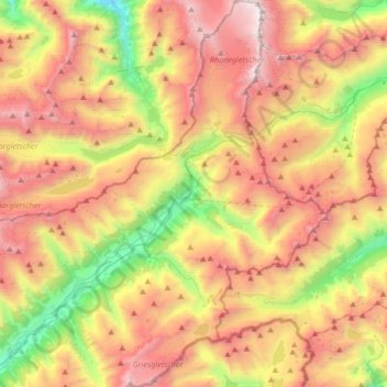
Nom : Carte topographique Obergoms, altitude, relief.
Lieu : Obergoms, Conches, Valais, Suisse (46.42362 8.25806 46.65405 8.47856)
Altitude moyenne : 2 306 m
Altitude minimum : 1 068 m
Altitude maximum : 3 593 m
Faire un don
Équipez-vous pour votre prochaine aventure :
En tant que Partenaire Amazon, ce site perçoit une commission sur les achats éligibles sans surcoût pour vous.
Autres cartes topographiques
Cliquez sur une carte pour visualiser sa topographie, son altitude et son relief.
Glacier d'Aletsch
Suisse > Valais > Conches > Fieschertal
Sa longueur est de 23,6 kilomètres (en décembre 2001) pour une superficie de 117,6 km2 (ou 128 km2 selon la commission d'évaluation de l'Unesco) et une masse de 27 milliards de tonnes de glace,. Sa partie médiane avance à une vitesse de l'ordre de 180 à 200 mètres par an. Neuf sommets qui l'entourent…
Altitude moyenne : 2 532 m
Finsteraarhorn
Suisse > Valais > Conches > Fieschertal
Le Finsteraarhorn, culminant à 4 274 mètres d'altitude, est le plus haut sommet du massif des Alpes bernoises, à la frontière entre les cantons du Valais et de Berne en Suisse. Vu du sud-est, il se présente comme une pyramide élancée qui se redresse en s'approchant du sommet. Compte tenu de son…
Altitude moyenne : 3 420 m
Oberwald
Suisse > Valais > Conches > Conches-les-haut
La commune, située à l'extrémité orientale du canton du Valais, à 44 km au nord-est de la gare de Brigue, comprenait le village d'Oberwald, situé à 1370 m d'altitude, sur la rive droite du Rhône et, depuis 1838, celui d'Unterwassern, qui occupe le fond plat de la rive gauche, le Gerental avec les…
Altitude moyenne : 1 744 m
Faire un don
Équipez-vous pour votre prochaine aventure :
En tant que Partenaire Amazon, ce site perçoit une commission sur les achats éligibles sans surcoût pour vous.
Finsteraarhorn
Suisse > Valais > Conches > Fieschertal
Le Finsteraarhorn, culminant à 4 274 mètres d'altitude, est le plus haut sommet du massif des Alpes bernoises, à la frontière entre les cantons du Valais et de Berne en Suisse. Vu du sud-est, il se présente comme une pyramide élancée qui se redresse en s'approchant du sommet. Compte tenu de son…
Altitude moyenne : 3 420 m
Faire un don
Équipez-vous pour votre prochaine aventure :
En tant que Partenaire Amazon, ce site perçoit une commission sur les achats éligibles sans surcoût pour vous.