
Carte topographique Andorre-la-Vieille
Carte interactive
Cliquez sur la carte pour afficher l’altitude.
Andorre-la-Vieille
Andorre-la-Vieille (en catalan : Andorra la Vella) est le nom de l'une des sept paroisses (parròquia) et la capitale de la Principauté d'Andorre. La paroisse compte de nos jours un peu plus de 22 000 habitants, 19 000 pour la ville elle-même. Elle se situe sur la rivière Valira (ou Gran Valira), peu après la confluence du Valira d'Orient et du Valira del Nord (située dans la paroisse d'Escaldes-Engordany), à environ 1 013 m d'altitude, ce qui en fait la plus haute capitale nationale d'Europe.
À propos de cette carte
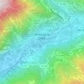
Nom : Carte topographique Andorre-la-Vieille, altitude, relief.
Lieu : Andorre-la-Vieille, Andorra la Vella, AD500, Andorre (42.49665 1.50531 42.51348 1.53425)
Altitude moyenne : 1 270 m
Altitude minimum : 978 m
Altitude maximum : 2 115 m