
Carte topographique Saint-Genis-Pouilly
Carte interactive
Cliquez sur la carte pour afficher l’altitude.
Saint-Genis-Pouilly
L'altitude de la commune varie de 419 mètres (à l'extrémité sud de la commune, au confluent entre l'Allondon et le Nant de l'Ecra) à 502 mètres (à l'extrémité nord de la commune, dans le hameau de Flies).
À propos de cette carte
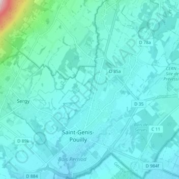
Nom : Carte topographique Saint-Genis-Pouilly, altitude, relief.
Altitude moyenne : 485 m
Altitude minimum : 425 m
Altitude maximum : 1 065 m
Autres cartes topographiques
Cliquez sur une carte pour visualiser sa topographie, son altitude et son relief.
Mont Myon
France > Auvergne-Rhône-Alpes > Ain > Val-Revermont
Le mont Myon est un sommet du massif du Jura culminant à 662 m d'altitude.
Altitude moyenne : 470 m
La Gaîté
France > Auvergne-Rhône-Alpes > Ain > Châtillon-sur-Chalaronne > Châtillon-sur-Chalaronne
Altitude moyenne : 252 m
Plateau de Vergongeat
France > Auvergne-Rhône-Alpes > Ain > Coligny > Vergongeat
Altitude moyenne : 449 m
Les Grandes Cadalles
France > Auvergne-Rhône-Alpes > Ain > Saint-Denis-lès-Bourg
Altitude moyenne : 232 m
Saint-Benoît
France > Auvergne-Rhône-Alpes > Ain > Groslée-Saint-Benoit
La commune de Saint-Benoît est composée d'un village principal (Saint-Benoît) et de plusieurs hameaux disséminés entre le Rhône et la montagne, dont le sommet principal (la Grayes) élève à 781 m d'altitude sa noire chevelure de sapins. La commune se situe dans la zone d'appellation contrôlée des vins du Bugey.
Altitude moyenne : 316 m