
Carte topographique Erfurt
Carte interactive
Cliquez sur la carte pour afficher l’altitude.
Erfurt
La ville est adossée au sud sur les hauteurs boisées de la forêt de Steigerwald ainsi que sur la forêt de Thuringe un peu plus au sud. Son altitude minimale est de 158 m près du village de StotternheimStotternheim au nord et son altitude maximale approche les 430 m au sud-est aux alentours de Windischholzhausen.
À propos de cette carte
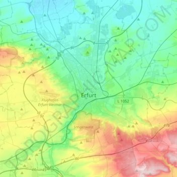
Nom : Carte topographique Erfurt, altitude, relief.
Lieu : Erfurt, Thuringe, Allemagne (50.89049 10.85467 51.07988 11.17514)
Altitude moyenne : 251 m
Altitude minimum : 153 m
Altitude maximum : 495 m
Autres cartes topographiques
Cliquez sur une carte pour visualiser sa topographie, son altitude et son relief.
Kernberg
Allemagne > Thuringe > Landkreis Schmalkalden-Meiningen > Floh-Seligenthal
Altitude moyenne : 694 m
Lichtenhain
Allemagne > Thuringe > Landkreis Saalfeld-Rudolstadt > Schwarzatal > Lichtenhain
Altitude moyenne : 559 m
Eisenach
Allemagne > Thuringe > Eisenach
Eisenach est construite sur la rive gauche de l'Hörsel, affluent de la Werra dans laquelle elle se jette quelques kilomètres en aval dans le village de Hörschel. Les villages de Neuenhof et Wartha sont d'ailleurs situés dans la vallée de la Werra. L'altitude la plus basse du territoire communal, au…
Altitude moyenne : 290 m
Sondershausen
Allemagne > Thuringe > Kyffhäuserkreis > Sondershausen > Sondershausen
Altitude moyenne : 292 m
Söllnitz
Allemagne > Thuringe > Landkreis Weimarer Land > Blankenhain > Söllnitz
Altitude moyenne : 375 m