
Faire un don
Équipez-vous pour votre prochaine aventure :
En tant que Partenaire Amazon, ce site perçoit une commission sur les achats éligibles sans surcoût pour vous.
Carte topographique Darian
Cliquez sur la carte pour afficher l’altitude.
Faire un don
Équipez-vous pour votre prochaine aventure :
En tant que Partenaire Amazon, ce site perçoit une commission sur les achats éligibles sans surcoût pour vous.
À propos de cette carte
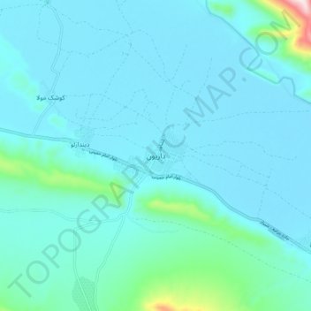
Nom : Carte topographique Darian, altitude, relief.
Lieu : Darian, دهستان داریان, Shiraz County, Fars Province, Iran (29.52006 52.88233 29.60006 52.96233)
Altitude moyenne : 1 642 m
Altitude minimum : 1 575 m
Altitude maximum : 2 042 m
Faire un don
Équipez-vous pour votre prochaine aventure :
En tant que Partenaire Amazon, ce site perçoit une commission sur les achats éligibles sans surcoût pour vous.
Autres cartes topographiques
Cliquez sur une carte pour visualiser sa topographie, son altitude et son relief.
Shiraz
Iran > Fars Province > Shiraz County
Shiraz's climate has distinct seasons, and is overall classed as a cold semi-arid climate (Köppen climate classification BSk), though it is only a little short of a hot semi-arid climate (BSh) or a hot-summer Mediterranean climate (Köppen climate classification Csa). Summers are hot, with a July average high…
Altitude moyenne : 1 785 m
Shiraz
Iran > Fars Province > Shiraz County
Shiraz's climate has distinct seasons, and is overall classed as a cold semi-arid climate (Köppen climate classification BSk), though it is only a little short of a hot semi-arid climate . Summers are hot, with a July average high of 37.9 °C (100.2 °F). Winters are cool, with average low temperatures below…
Altitude moyenne : 1 785 m
Shiraz
Iran > Fars Province > Shiraz County
Shiraz's climate has distinct seasons, and is overall classed as a semi-arid climate (Köppen climate classification BSh, bordering BSk). Summers are hot, with a July average high of 38.7 °C (101.7 °F). Winters are cool, with average low temperatures below freezing in January. Around 320 mm (13 in) of rain…
Altitude moyenne : 1 785 m
Faire un don
Équipez-vous pour votre prochaine aventure :
En tant que Partenaire Amazon, ce site perçoit une commission sur les achats éligibles sans surcoût pour vous.